Glocknerman ULTRA
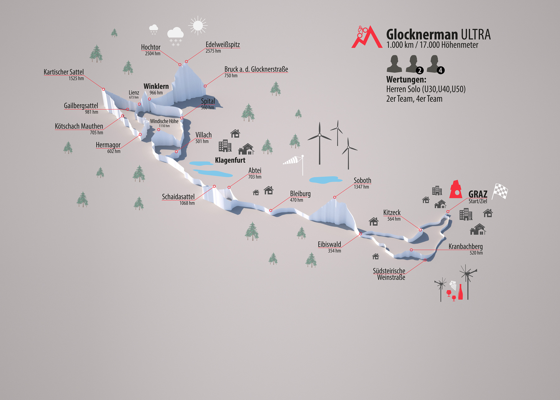
With 1000 km and 17.000 metres of altitude the Ultra route leads the athletes under 50 years of age and teams from Graz to Winklern, through the Lesachtal, twice on the Großglockner and back to Graz.
Data
Kilometer: 1000 km
Altitude: 16000 hm
Categories
- Solo Men (U30,U40,U50)
- Solo Women
- 2-person Team
- 4-person Team
Teams: There is one overall ranking independend if the athletes are male, mixed or female.
World championship disciplines
- Men U30
- Men U40
- Men U50
- Women
Route

Click to enlarge
Route description
Start: Center West/Graz - Unterpremstätten – Zwaring – Preding – Kitzeck im Sausal 564m – Gleinstätten – Eibiswald – Soboth 1.347m – Lavamünd -
Bleiburg – Sittersdorf – Eisenkappel - Schaidasattel 1.069m – Zell - Ferlach – Feistritz im Rosental – Maria Elend – Sankt Jakob im Rosental –
Finkenstein – Villach – Spittal an der Drau – Stallhofen - Obervellach – Kleindorf - Winklern - Iselsberg 1.204m – Oberdrauburg – Greifenburg –
Kreuzberg 1.077m – Weißbriach – Hermagor – Dellach – Kötschach-Mauthen – Sankt Lorenzen im Lesachtal - Maria Luggau – Obertillach – Kartitscher Sattel 1.530m –
Tassenbach – Lienz - Iselsberg 1.204m – Winklern – Döllach – Heiligenblut – Hochtor 2.504m – Edelweißspitze 2.572m – Fusch an der Großglocknerstraße –
Bruck an der Großglocknerstraße - Hochtor 2.504m – Heiligenblut – Döllach – Winklern – Kleindorf – Obervellach – Stallhofen – Spittal an der Drau –
Paternion – Windische Höhe 1.110m – Arnoldstein – Finkenstein – Sankt Jakob im Rosental – Maria Elend – Feistritz im Rosental – Ferlach –
St. Margareten im Rosental - Abtei 701m –– Bad Eisenkappel – Sittersdorf – Bleiburg – Lavamünd - Soboth 1.347m - Eibiswald – Oberhaag – Arnfels –
Leutschach – Kranachberg 478m – Gamlitz – Ehrenhausen – Landscha an der Mur – Neutillmitsch – Lebring – Wildon – Kalsdorf bei Graz – Feldkirchen bei Graz -
Ziel: Center West/Graz
Timestation
Timestations are important places on the route, they are marked in the Roadbook and in the gps-files.
At the timestation the passage time has to be reported to the race control.
| Timestation | KM | Section length | Altitude | Section- Altitude |
| Start: Graz / Center West | 0,0 | 0,0 | 0,0 | 0,0 |
| Kitzeck | 37,8 | 37,8 | 500,0 | 500,0 |
| Gleinstätten | 9,9 | 47,7 | 30,0 | 530,0 |
| Soboth | 41,1 | 88,8 | 1391,0 | 1921,0 |
| Schaidasattel | 57,8 | 146,6 | 684,0 | 2605,0 |
| Villach | 67,6 | 214,2 | 729,0 | 3334,0 |
| Winklern 1 | 95,4 | 309,6 | 1277,0 | 4611,0 |
| Hermagor | 70,3 | 379,8 | 1021,0 | 5632,0 |
| Kartitscher Sattel | 71,9 | 451,7 | 1739,0 | 7371,0 |
| Winklern 2 | 50,0 | 501,7 | 718,0 | 8089,0 |
| Heiligenblut | 22,1 | 523,8 | 472,0 | 8561,0 |
| Hochtor 1 | 14,7 | 538,5 | 1336,0 | 9897,0 |
| Edelweißspitze | 8,1 | 546,6 | 300,0 | 10197,0 |
| Bruck/Großglocknerstraße | 27,9 | 574,5 | 0,0 | 10197,0 |
| Hochtor 2 | 32,5 | 607,0 | 1985,0 | 12182,0 |
| Winklern 3 | 36,6 | 643,7 | 208,0 | 12390,0 |
| Windische Höhe | 89,6 | 733,3 | 1149,0 | 13539,0 |
| Abtei | 94,9 | 828,2 | 1435,0 | 14974,0 |
| Soboth | 66,5 | 894,6 | 1531,0 | 16505,0 |
| Kranachberg | 48,9 | 943,6 | 300,0 | 16805,0 |
| Wildon | 32,0 | 975,5 | 100,0 | 16905,0 |
| Ziel: Graz / Center West | 21,0 | 996,5 | 30,0 | 16935,0 |
The kilometres of CityRadeln are not included.
You can find all .gpx-files of the route under Documents


